The "Final Review Meeting of the Top Ten National Archaeological Discoveries of 2024" was held in Beijing from April 23 to 24. The Paper learned from the State Administration of Cultural Heritage that the final review committee announced the results this morning after review and voting. The final shortlisted sites are: Mengxi River Ruins Group in Ziyang, Sichuan, Xiatang Ruins in Xianju, Zhejiang, Siwa Ruins in Lintao, Gansu, Kangmamabuoxiang Ruins in Tibet, Panlongcheng Ruins in Huangpi, Hubei, Zhouyuan Ruins in Baoji, Shaanxi, Liulihe Ruins in Fangshan, Beijing, Wuwangdun Tomb No. 1 in Huainan, Anhui, Hebosuo Ruins in Jinning, Yunnan, and Kashgar More Temple Ruins in Xinjiang.
List of the top ten archaeological discoveries in China in 2024 (in order of age)
Mengxi River Site Group, Ziyang City, Sichuan Province
1. Overview of the Site
The origin of modern humans in East Asia is a hot topic among academia and the public. The Mengxi River site cluster, represented by the Mengxi River site in Ziyang City, Sichuan Province, provides systematic and new evidence for solving this mystery.
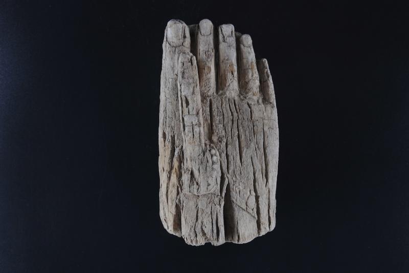
The first site of the Mengxi River Ruins Group (i.e. the Mengxi River Site) was discovered in 2021, with an area of approximately 12,000 square meters. With the approval of the State Administration of Cultural Heritage, the Sichuan Provincial Institute of Cultural Relics and Archaeology and the Institute of Vertebrate Paleontology and Paleoanthropology, Chinese Academy of Sciences, carried out archaeological excavations from 2022 to 2024, with a total excavation area of 300 square meters, including 50 square meters in 2024. A total of 15,100 numbered stone tools and fossil specimens, 2,100 large and medium-sized wooden relics have been unearthed, 17,900 soil samples of various types have been collected (12,700 have been floated), 62,200 pieces of plant seeds and fruits have been selected, and 202,000 stone products and fossil fragments. The simultaneous investigation confirmed a Mengxi River culture-type site cluster consisting of 86 sites, which are widely distributed in the shallow hilly landform areas of the Tuojiang and Fu river basins. Its cultural features are characterized by the use of petrified wood as the main raw material for stone tools, and the production of small stone tool assemblages mainly consisting of scrapers; more than 120 petrified wood raw material sites were discovered simultaneously. The archaeological team insisted on problem-oriented and protection at the same time, and carried out multidisciplinary comprehensive research in conjunction with authoritative experts from home and abroad. Dating showed that the site was between 80,000 and 60,000 years ago, which is a key stage in the evolution of modern humans. At the same time, the water-saturated burial environment of the site extremely rarely preserves a relatively complete ancient society. It is an internationally rare "general-purpose" site that contains rich stone tools, animal and plant remains. It is the only site in the stage of the origin and spread of modern humans where rich plants have been found, and it has confirmed a series of evidence of the earliest domestic and international stages of behavioral modernity.

Mengxi River Site Group in Ziyang City
II. Main Value and Significance
1. The discovery of the siliceous rock microlithic industry at the Mengxi River site group, which dates back about 100,000 to 50,000 years, systematically fills the gap in the culture of this stage from southern China to Southeast Asia, and provides key empirical evidence for the study of the early and middle stone culture transition in East Asia. This stone tool culture is the first stable type discovered in South China, and is clearly different from the large pebble stone tool industry in the south. It is both consistent with and innovatively developed from the simple core and flake technology of East Asia, showing the cultural characteristics of early modern people in East Asia who were flexible and adaptable to local conditions.
System scratch marks
2. Confirm the behavioral characteristics of early modern humans in southern China. Stone tools, bone tools and internationally rare wooden tools form a three-dimensional tool system. The diverse carvings and perforations are evidence of the first concentrated and systematic emergence of symbolic behavior in East Asia. Combined with other discoveries and utilization evidence such as animals and plants, it forms the most complex and earliest series of behavioral modernity collections in the world during the same period, showing the complexity of consciousness and social behavior of early modern humans in East Asia, and providing systematic new evidence for understanding its origin and development.
Some animal fossils
3. The unprecedentedly rich animal and plant remains, especially plant remains, fill the gap in plant discovery and utilization at this stage. Animals include the earliest domestic and even international evidence of the utilization of aquatic animals (fish, turtles, etc.), large carnivorous animals (bears, tigers, etc.) and birds. The plants include berries (grapes, blackberries, etc.), nuts (walnuts, acorns, etc.) and a large number of other edible types (peppercorns, elderberries, etc.), totaling 37 families and 53 genera. Many of the plants were first discovered in archaeological sites. At the same time, a large amount of evidence of animal and plant utilization was found, including systematic use of fire, cutting, chopping and smashing, centralized treatment of saber-toothed elephants, and special areas such as acorn enrichment.
Some plant seeds
The Mengxi River reveals for the first time the gathering economy of humans in the Middle Paleolithic Age and their ability to recognize and utilize plant resources, bringing forward the "broad spectrum revolution" in food that was thought to have occurred at a later period. It provides unique new materials for understanding the behavior of early modern humans in East Asia and even the world, and systematically and comprehensively reveals the complete "diet" of early modern humans. Among them, the extraction of medicinal plant information has created new areas and new records in the study of human evolutionary history.
4. The discovery of a new type of microlithic culture and site clusters in the local tradition of South China, the confirmation of a series of modern human behaviors, the extensive use of animals and plants, and the restoration of the habitat forms and landscapes of the early Late Pleistocene clearly show the historical scenes at the key nodes of millions of years of human history, filling the key time, space, human behavior and cultural gaps in the study of modern human evolution. It strongly proves that the ancient humans in East Asia, who were previously considered to be relatively "backward", were not silent. On the contrary, their stone tool technology not only inherited local traditions, but also actively developed various complex modern behaviors. It is a major breakthrough in the understanding of a series of major international academic issues, especially the origin and evolution of modern humans in East Asia and the long-standing early cultural development.
Xiatang Site in Xianju, Zhejiang
1. Overview of the Site
The Xiatang Site is located in Xiatang Village, Hengxi Town, Xianju County, Taizhou City, Zhejiang Province. The site is located on a natural platform in the center of a basin in the upper reaches of Lingjiang River, 1 to 2 meters higher than the surrounding farmland, bordering the water on the east and west, and about 2 kilometers south of Lingjiang River.
The site was discovered in 1984; in 2015, the Zhejiang Provincial Institute of Cultural Relics and Archaeology conducted an exploration of it; in 2018, formal archaeological excavations were carried out; in 2023, it was included in the "Archaeology China-Research on the Formation of Early Rice-Growing Agricultural Society in the Middle and Lower Reaches of the Yangtze River" project. The total excavation area has reached 2,250 square meters.
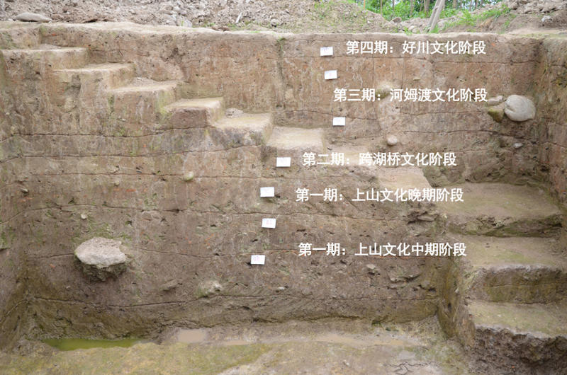
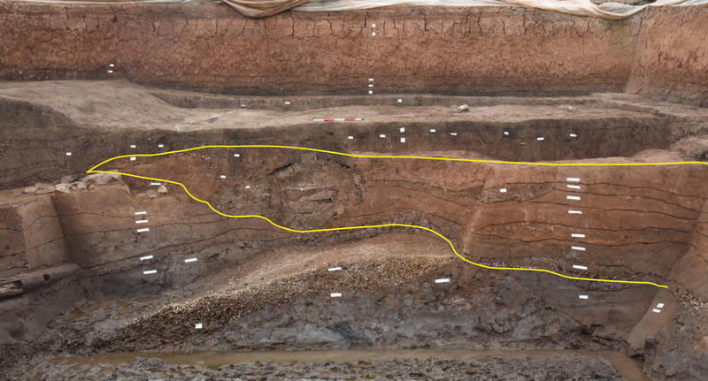
Central stratigraphic section of the site
II. Main Achievements
Work over the years has shown that the Xiatang site is an important Neolithic settlement site. The site is an irregular circle with an area of about 30,000 square meters. The cultural layer is 2.5 meters thick and includes four stages: Shangshan culture, Kuahuqiao culture, Hemudu culture, and Haochuan culture. The absolute age of the site is about BP9300-BP4000.
Archaeology has revealed the triple settlement structure and its dynamic development process of the middle and late Shangshan culture at the Xiatang site around 9,000 years ago, consisting of a central platform, an outer artificial earth platform, and a moat. The relics are rich and complete, including moats, artificial earth platforms, artifact pits, ash pits, house sites, tombs, food processing plants, red-baked earth "square" relics, trenches, ditches, roads, etc., which preliminarily outline the life scene of the ancient village of Xiatang.
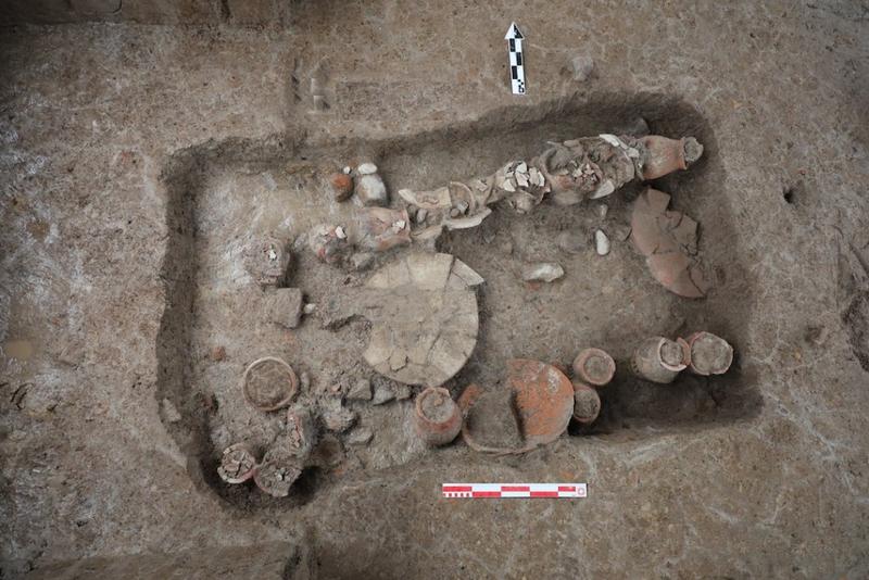
High-level tomb M2
3. Value and Significance
1. The Xiatang site reveals the triple settlement structure of the central terrace, the outer artificial earth platform and the moat during the middle and late Shangshan culture around 9,000 years ago, and its dynamic development process. The relics are rich and complete in types, including moats, artificial earth platforms, house sites, artifact pits, ash pits, tombs, food processing plants, red-baked earth squares, ditches, trenches, roads and other relics, presenting a panoramic view of the settlement form and structure of the early agricultural society.
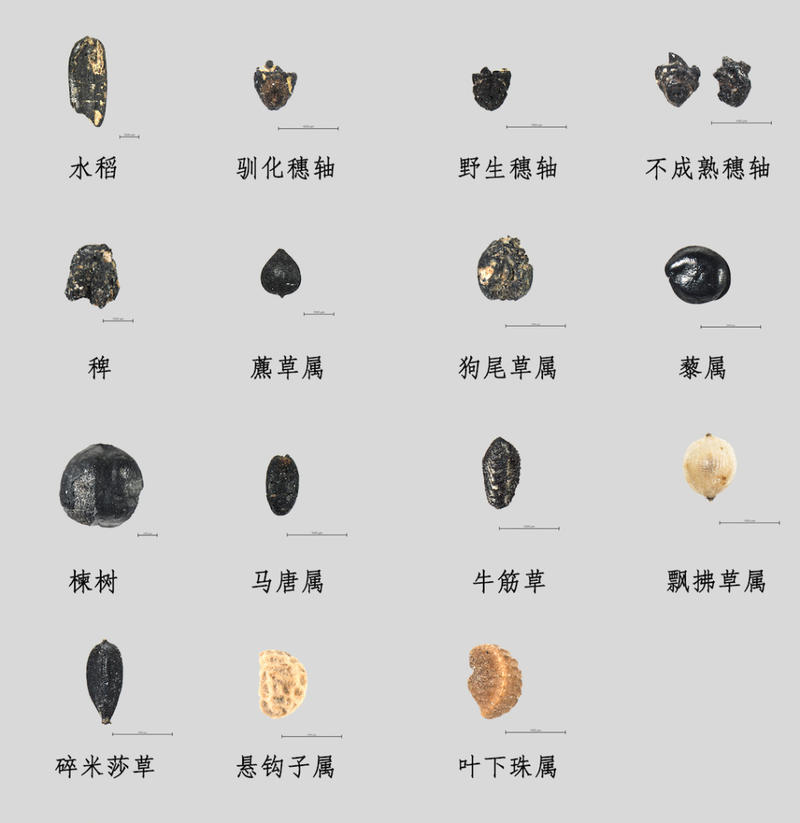
Plant remains unearthed from the Shangshan culture period
2. The relationship between the central terrace and the outer artificial earth platforms reflects a centripetal social structure. Each earth platform may correspond to a basic social organization unit. This is a major breakthrough in the social structure of the early Neolithic period. The emergence of high-level tombs has refreshed the understanding of the early social process.
3. The rich multidisciplinary research results of the Xiatang site will provide academic support and methodological examples for a comprehensive understanding of the environment, technology, subsistence economy, society, concepts and behaviors of the Shangshan culture, and for the restoration and reconstruction of the early rice-growing agricultural society.
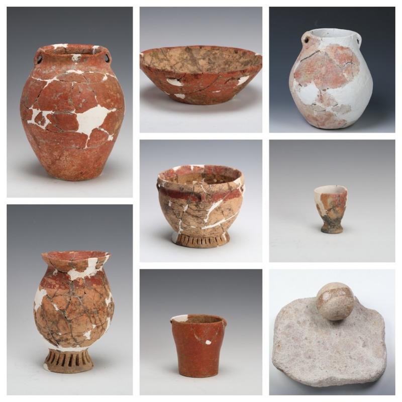
Typical artifacts of Shangshan culture unearthed
4. The Xiatang site has gone through the Shangshan Culture, Kuahuqiao Culture, Hemudu Culture, and Haochuan Culture, spanning the entire Neolithic Age, establishing and improving the archaeological cultural sequence of this region. It is an important empirical evidence of the 10,000-year cultural history and 10,000-year civilization of the early rice-growing agricultural society in southern my country. Moreover, in the academic context where the settlement morphology and social structure of early Neolithic sites are generally unclear, Xiatang provides a very important sample for the study of early agricultural society.
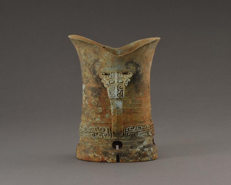
Siwa Ruins in Lintao, Gansu
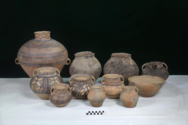
Majiayao culture is one of the most important archaeological cultures in the upper reaches of the Yellow River. It is mainly distributed in the upper reaches of the Yellow River and its tributaries Taohe, Huangshui and Weihe rivers, covering the present-day provinces of Gansu, Qinghai, Ningxia, Sichuan and Shaanxi. It is characterized by the production and use of painted pottery and dates back about 5,000 to 4,000 years. The Majiayao culture created the pinnacle of prehistoric painted pottery art and had a lasting and far-reaching impact on Chinese civilization. Its archaeological work is of great significance in filling the gaps in the northwest region in the study of the origins of Chinese civilization.
The Siwa site is located in Siwashan Village, Lintao County, Dingxi City, Gansu Province, and is the place where the Siwa culture was named. The site is located west of Jiulong Mountain and faces Tao River, with an area of about 2 million square meters. The site was first discovered by Andersson in 1924, and Xia Nai began archaeological excavations here in 1945. From 2018 to 2024, the Institute of Archaeology of the Chinese Academy of Social Sciences and the Gansu Provincial Institute of Cultural Relics and Archaeology jointly carried out seven excavations at the site, revealing an area of nearly 4,000 square meters, and discovered and excavated a large settlement of the Majiayao culture and a large cemetery of the Siwa culture.
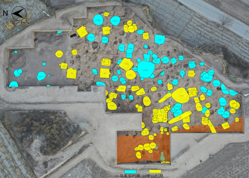
Distribution map of important relics in the excavation area in the northwest corner of the inner side of the "moat (ditch)" (the top is the east; blue is the Majiayao type, yellow is the Banshan type)
The large settlement of Majiayao culture is located in the central and eastern part of the site. Three rectangular "moats (ditches)", nearly 100 house sites, a large number of ash pits, more than ten pottery kilns and several tombs have been discovered. There are also clues of suspected "roads" and large areas of "artificial earth piles". The era continued from the Majiayao type to the Banshan type, and important breakthroughs have been made in many aspects:
1. The first large-scale "moat (ditch)" with a triple rectangular layout in prehistoric times was discovered.
The three "moats (trenches)" are distributed in parallel, connecting to Hongshuigou in the north, turning at a right angle in the southwest, and reaching the cliff in the east. The existing structure is about 600 meters long from east to west and about 450 meters wide from north to south, with an internal restoration area of nearly 300,000 square meters. The width of the three ditch mouths is about 9-11 meters, the middle and outer circles are about 3-4 meters deep, the inner circle is about 1.3-2.5 meters deep, and the distance between them is about 8-9 meters. There are passages in many places, and they are roughly corresponding to each other. It should be a large-scale project built after careful planning and measurement. Judging from the shape and layout, internal accumulation and unearthed relics, the three should have existed and been used at the same time, but with different functional natures. The middle circle and the outer circle are "moats", which have both defense and drainage functions; the inner circle is a "ditch"-like production and living area distributed along the "moats". It was first built and mainly used during the Majiayao period, about 5,000 years ago. It is the earliest known "moat (ditch)" structure with multiple rectangular layouts in China, and laid an early foundation for the emergence of rectangular "cities" in later generations.
2. The inner side of the "moat" is rich in content, and many handicraft production and living areas have been discovered.
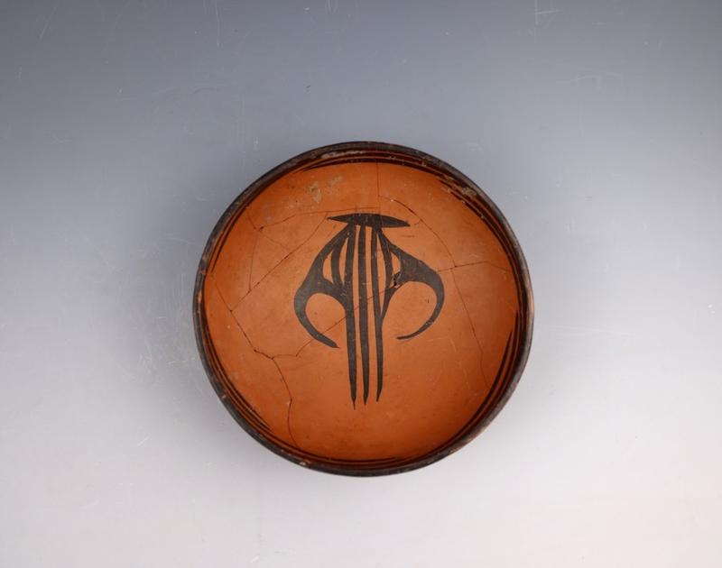
Dozens of Majiayao-type house sites, a large number of ash pits and cellars, and several pottery kilns were discovered inside the "moat", in the inner circle "ditch" and in the surrounding areas, distributed in a sheet-like manner. Combined with the discovery of mud storage pits, pottery making tools and fired waste products from the same period, it can be determined that there were multiple pottery making areas inside the "moat", and there were stone processing workshops around it. Complete sets of stone drills, stone rings, semi-finished products and waste materials were unearthed, highlighting the unique position of handicraft production in Majiayao society. The layout of the pottery-making area is novel and it is likely to be a regional pottery-making center. The achievements of Majiayao culture in pottery making, especially the production and use of painted pottery, reached a peak in prehistoric times.
2021GLSM120 (above is slightly south of west)
3. Outside the “trench”, suspected “roads” and a large area of “artificial soil piles” were found.
On the west side of the "moat", clues of a suspected Majiayao-type "road" and a large area of "artificial earth pile" were found. There seem to be traces of tamping on some of the "artificial earth piles", and both the "artificial earth piles" and the suspected "roads" are close to the "moat" passage, reflecting the meticulous planning, rich connotations and level of civilization achieved by the large-scale settlement of the Majiayao culture at the Siwa site. Regular rammed earth building foundations were also discovered on the west side of the site near the mountain, and the age of the building is yet to be confirmed.
4. The first large-scale Banshan-type settlement of the Majiayao culture was discovered.
Inside the "moat", a number of Banshan-type house sites, ash pits, cellars, pottery kilns and tombs were discovered. Together with the "moat" that still existed at that time, they constituted an important part of the Banshan-type settlement, filling the gap in the discovery of Banshan-type settlements. This is also the first time that human burials have been discovered in Banshan-type houses. The discovery of the Banshan-type settlements is also of great significance for the study of early cultural exchanges between the East and the West, especially the introduction and early development of some important livelihood technologies such as metallurgy, as well as sheep, cattle, and wheat crops.
2021GLSM120 Unearthed Pottery
5. The high-level, central settlement of the Majiayao culture was confirmed for the first time.
The large-scale Majiayao culture settlement at the Siwa site is the largest, most richly endowed and highest-level large-scale Majiayao culture settlement known to date. The settlement is divided into two parts by the "moat", with a total area of over one million square meters. At the southern end of the Tao River Valley where the site is located, there are dozens of sites of different sizes from the same period, forming a Majiayao culture settlement group. The Siwa site is a leader among them and should be a central settlement of the Majiayao culture.
Majiayao type painted pottery 2022GLSH781
The large-scale Majiayao culture settlement at the Siwa site demonstrates the level of development and civilization of the early society in the western part of the Loess Plateau 5,000 years ago. It fills the gap in the critical period of the core hinterland of the upper reaches of the Yellow River in the study of the origins of Chinese civilization and enriches the "pluralistic and unified" pattern of the origin and early development of Chinese civilization. The Majiayao culture developed from the Yangshao culture and expanded towards the northwest and southwest. It was based on agricultural production and characterized by high-level specialized painted pottery production, exchange and trade. It created the pinnacle of prehistoric painted pottery art, gave birth to many archaeological cultures in the west, opened up an early channel for communication between the East and the West, and demonstrated the profoundness and long history of Chinese civilization.
Kangmama Neolithic Site in Tibet
Issues such as the Neolithicization, settlement, agro-pastoralism, population migration and cultural exchange on the Qinghai-Tibet Plateau are hot topics that have attracted great attention from the international academic community. Since 2018, the Tibet Autonomous Region Institute of Cultural Relics Protection, the Institute of Tibetan Plateau Research, Chinese Academy of Sciences and other units have jointly carried out a series of field work around the above-mentioned issues in conjunction with the second comprehensive scientific expedition to the Qinghai-Tibet Plateau. The site was first discovered in 2019. From 2020 to 2024, with the approval of the State Administration of Cultural Heritage, the Tibet Autonomous Region Institute of Cultural Relics Protection, in collaboration with the Qinghai-Tibet Plateau Institute of the Chinese Academy of Sciences, Lanzhou University, Peking University, the Archaeological Research Center of the State Administration of Cultural Heritage and other units, carried out five years of field excavations.
Schematic diagram of the stages of the ruins of Mabuluo
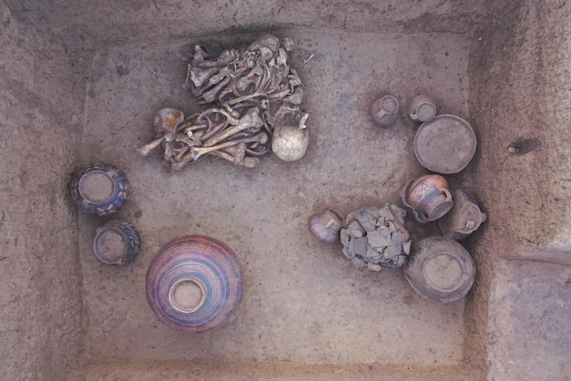
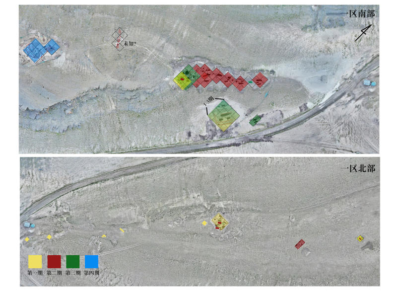
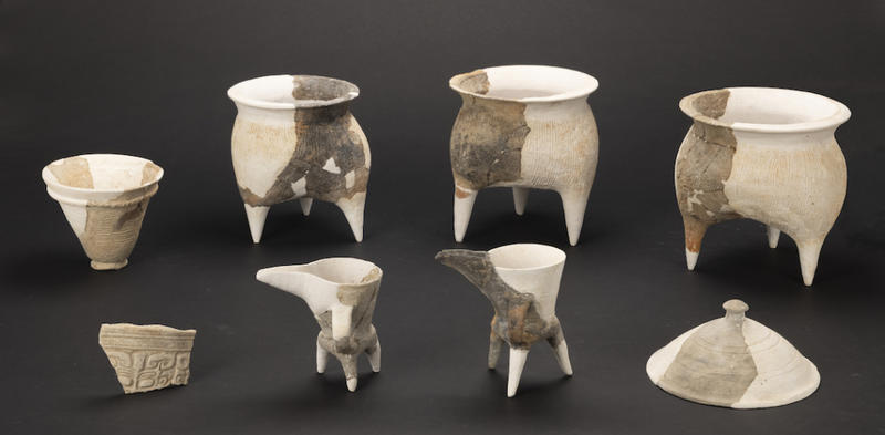
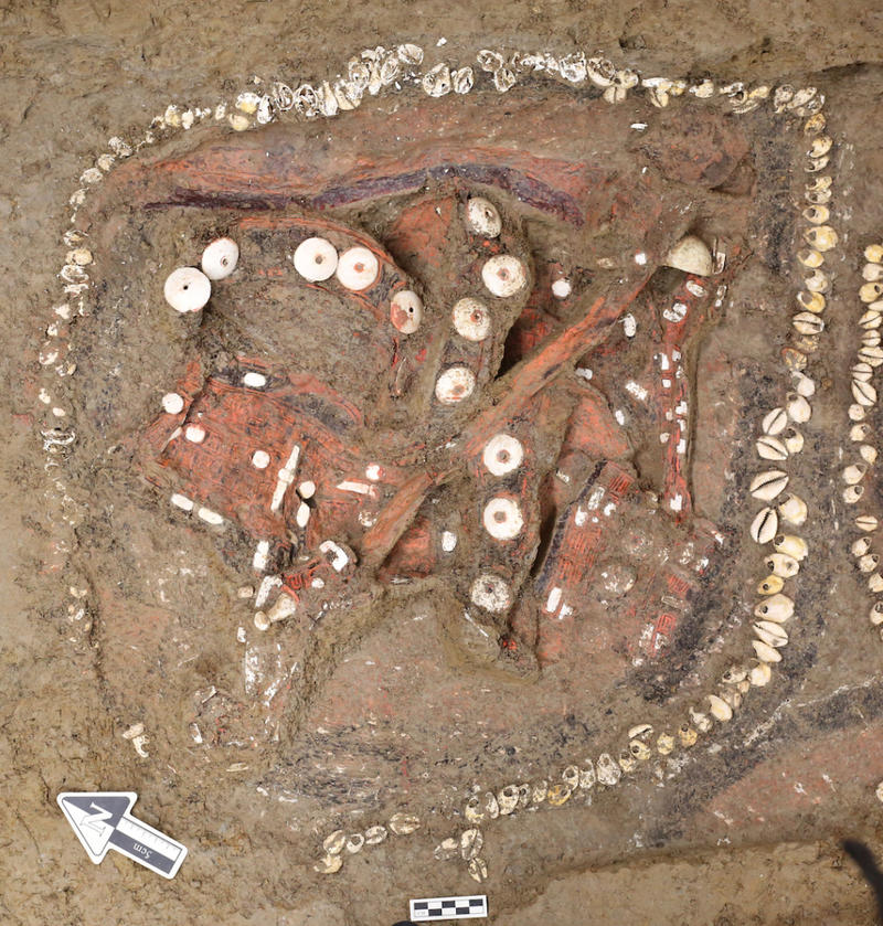
The Ma Ma Kou Ruins are located on the shore of Ma Ma Kou Lake, northeast of the seat of Gala Township Government of Kangma County in south-central Tibet, on the border between China and India and China and Bhutan. It is located on a plateau on the northern wing of the middle Himalayas, at an altitude of 4,410-4,430 meters. According to the topography and distribution characteristics of the relics, the site can be divided into three areas, mainly distributed on the south bank, southeast bank and northwest bank of Lake Mamawo. Area I is located on the hillside, ridge and the eastern and western slopes of the ridge on the southeast shore of the lake, Area II is located on the pass slope on the south shore of the lake; Area III is located on the alluvial slope in the northwest of the lake. The site covers an area of more than 224,000 square meters, of which 1,650 square meters have been excavated so far. A total of 61 tombs, 43 ash pits, 8 pillar holes, 5 activity surfaces, 4 stoves, 2 fire pits, and 2 stone structure sites have been cleared. The types of tombs include sarcophagus tombs, vertical pit tombs, and stone chamber tombs; the burial styles include prone burial with straight limbs, secondary bone-picking burial, sideways burial with bent limbs, supine burial with the chest embraced and limbs straight, upper and lower stacking burials, and corpse cremation.
According to the comprehensive characteristics, the site can be divided into four periods.
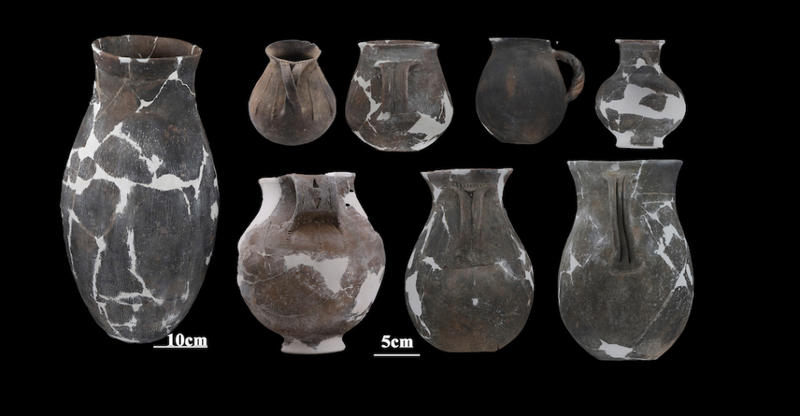
The first phase of remains dates back 5,000 to 4,000 years, and is represented by polished flat-bottomed jars with wide mouths and flat-bottomed basins with folded bellies decorated with developed stamped and scratched patterns. Various types of bone and clam tools and fine stone tools made of crystal were popular. The main cultural layers are Area I and prone straight-limbed sarcophagus tombs. Special burial customs include supine burials with cremation inside tombs. Among them, the remains dating back 5000 to 4500 years are distributed in Area III, mainly in local activity surfaces.
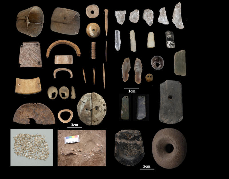
Typical bone and stone tools from the first period of Ma Nian Ge
The second phase remains date back 4000 to 3300 years and are distributed in tombs, ash pits and strata in the southern part of Area I. The main types of burials are vertical pit tombs, and the representative burial styles are sideways burials of opposite sexes in the same tomb, single person supine burials, and various types of upper and lower burials in the same tomb. Only two fire pits were found in Area II. The number and variety of burial objects are the highest among the four periods. Pottery was represented by a single-handled flat-bottomed jar made of brown pottery with mica and decorated with radial scratches. Strip-shaped pottery with handles became popular. Bone tools and microliths declined, and new relics such as bronze, agate, carnelian and faïence appeared.
Typical pottery of the second period of Ma Neng Le
The third phase remains date back 3300 to 3000 years and are distributed in the southern part of Zone I. The most representative type is the stone chamber tomb, which mainly practices bone burial, with few burial objects. There appeared larger-scale "stone-enclosed stone chamber tombs" and large vertical pit tombs with separate chambers, and on top of the larger-scale sarcophagus tombs there appeared a mound and its stone structure remains. In addition, a small stone chamber tomb with separate chambers was discovered. The pottery unearthed is represented by jars with folded rims, polished black-skinned pottery points and round bottoms. It continues the shape of some pottery from the second period and has a tendency to become smaller.
The fourth phase of remains dates back 3000 to 2000 years. The settlement layout seen in the excavation area has undergone a significant change, from a cemetery to a large stone structure with non-cemetery functions. At the same time, the remains of sacrificial ash pits appeared; the number of stone tools such as grinders, net pendants and simple stone cores and stone flakes increased sharply.
The discovery and research of the Mamabuxiang site broke through the temporal and spatial scope of the Neolithic process in Tibet for the first time. This site is the Neolithic lakeside site with the highest altitude, earliest age, longest duration, clearest cultural sequence and distinct cultural characteristics known in the central and southern Qinghai-Tibet Plateau.
The cultural features of the second and third phases of the Mabula site are significantly different from those of other discovered sites, representing a completely new archaeological cultural type - the "Mabula culture". This discovery is another milestone in the field of Neolithic archaeology in Tibet after the Karo and Qugong sites.
The Mamakou site demonstrates continuous development and evolution from the late Neolithic Age to the early Metal Age. It not only lays the foundation for constructing the long-term cultural pattern of the prehistoric Qinghai-Tibet Plateau hinterland, but also serves as a reference for other sites and related materials.
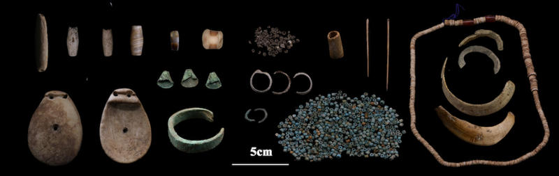
The second phase of Mabuhao relics (stone, bone, metal ornaments, bone needles, talc beads, carnelian, glass beads, etc.)
The numerous foreign relics discovered at the Mabula site, such as rice, millet, sorghum, seashells, ivory, sheep, bronze ware, talc beads, faions, carnelian, etc., not only fill many gaps in cross-regional cultural exchanges, but also have important reference significance for studying the inheritance and development of local culture in extreme environments.
The Mabula site is the first Neolithic site discovered in central Tibet more than 4,000 years ago. It not only provides important physical data for the construction of prehistoric Tibetan social history and archaeological cultural sequences, but also provides credible evidence for the interaction, communication, and integration of China's ethnic groups and the formation of the diversity and unity of Chinese civilization.
Panlongcheng Ruins in Huangpi, Hubei
The Panlongcheng Ruins are located in the northwest suburbs of Wuhan City, Hubei Province. The current administrative planning is under the jurisdiction of Yetian Village, Panlongcheng Economic Development Zone, Huangpi District, Wuhan City. The site is located on the northeastern edge of the Jianghan Plain, adjacent to Fuhe River, a tributary of the Yangtze River, in the south, and only 10 kilometers away from the main stream of the Yangtze River in the east. The Panlongcheng site was discovered in 1954, and large-scale archaeological excavations were carried out in the 1970s and 1980s, revealing that the site was a large urban settlement in the early Shang Dynasty, and its cultural features belonged to the Central Plains cultural system. The discovery of the Panlongcheng ruins not only proves the unified development of the Yellow River and Yangtze River civilizations, but also shows that the Yangtze River basin is also the cradle of Chinese civilization. Panlongcheng has therefore become a key site for exploring the civilization process in the middle reaches of the Yangtze River.
Aerial photography of Xiaozui excavation area
Since 2013, with the support of the National Cultural Heritage Administration's Archaeology China project "Research on the Process of Civilization in the Middle Reaches of the Yangtze River", a joint archaeological team has been formed by the School of History of Wuhan University, the Hubei Provincial Institute of Cultural Relics and Archaeology, the Wuhan Municipal Institute of Cultural Relics and Archaeology, and the Panlongcheng Site Museum. Focusing on the academic goal of the nature of the Panlongcheng urban settlement and the process of early civilization in the middle reaches of the Yangtze River, they have implemented the idea of large-scale archaeological work and carried out continuous archaeological work on the Panlongcheng site, one city at a time, for ten years.
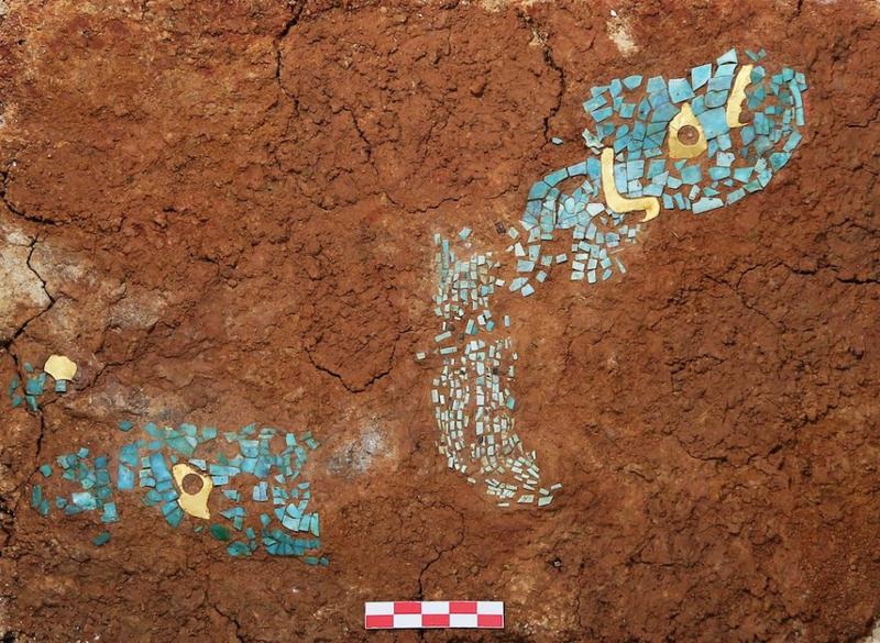
Gold and turquoise inlaid ornaments unearthed from Yangjiawan M17
1) Reveal the changes in urban settlements and show the early civilization process in the middle reaches of the Yangtze River. By combing through past data and years of archaeological excavations, we have revealed that the urban settlement center of Panlongcheng developed into three stages: from the early Wangjiazui, to the city site area, the Lijiazui high-level aristocratic burial area, the Xiaozui bronze casting workshop area, and finally moved to Yangjiawan in the latest stage. In the earliest stage of the city, the center of the settlement was located at Wangjiazui. Excavations at the Wangjiazui site in recent years have confirmed that the earliest stage of the Panlongcheng site can be traced back to the fourth phase of the Erlitou culture, providing empirical evidence of the influence of the Central Plains dynasty on the Yangtze River Basin in the late Xia Dynasty. The second stage of Panlongcheng's urban development lasted from the late period of the lower layer of Erligang to the first period of the upper layer, when a layout with the city site and the high-level aristocratic tombs of Lijiazui as the core began to take shape. In recent years, the Xiaozui bronze casting handicraft workshop area was discovered on the west side of the city site, showing the entire production process from mold making, casting, smelting, and finishing of bronze vessels, which further confirmed that Panlongcheng was able to cast bronze ritual vessels at this stage. During this period, Panlong City became the central city for the Central Plains Dynasty to control the south, with an area of nearly 1 million square meters. The third stage of urban development was the Middle Shang period, when the center of the settlement moved to Yangjiawan. Through years of systematic exploration and excavation on the southern slope of Yangjiawan, the foundations of large buildings and several high-ranking noble tombs of this period were discovered. At the same time, a burial area for small and medium-sized nobles and civilians was discovered at Xiaowangjiazui in the northern part of the site. The center of Panlongcheng urban settlement shifted northward, further reflecting the Central Plains dynasty's shift in management to the southern region.
A copper-belted goblet-shaped vessel unearthed from M 17 in Yangjiawan
2) Reconstruct the ancient landscape of the site and understand the regional hydrological changes and settlement environment. A water platform was built and underwater drilling was carried out in the waters around the Panlongcheng ruins, and signs of cultural accumulation were found under the silt layer. Further excavation of the anatomical trench was carried out on the lake beach on the east side of Xiaozui during the dry season, proving the existence of cultural deposits from the Shang Dynasty under the silt layer. According to calculations, the water level around the Shang Dynasty ruins should be lower than 17.5 meters above sea level, at least 5 to 7 meters lower than it is today. We further conducted multidisciplinary analysis of the core samples drilled from the lake bottom, including phytoliths and pollen, to confirm that the surrounding underwater environment was terrestrial during the Shang Dynasty. Returning to the stage of lower water levels during the Shang Dynasty, the Panlongcheng urban settlement should have been mainly distributed on hills and lakesides as we see it now, but should actually extend to the current lake bottom. The study of the landscape and environment of the Panlongcheng ruins revealed the trend of water level changes in the Jianghan area during the Xia and Shang dynasties based on archaeological evidence, providing important data for understanding the historical changes in the hydrology of the Yangtze River and the site selection of ancient and modern settlements.
Photos of the broken bronze tablet-shaped objects unearthed from Yangjiawan M17
3) Explore the remains of stone engineering projects to reflect the city’s complex structure and outstanding specifications. In 2015, archaeological exploration discovered signs of large-scale stone accumulation in the northern part of Yangjiawan, with an overall length of about 650 meters from east to west. After that, many years of archaeological work were carried out on the stone structure remains, including key drilling, ground penetrating radar and geomagnetic exploration, trench excavation, and partial exposure. In the excavation area in the middle of the northern slope of Yangjiawan, a nearly square foundation made of stone was discovered, 5 meters square. Several deeper ash pits and signs of complete buried pottery jars were found in the surrounding area. Soil structure analysis showed that the filling in the ash pits showed a rapid burial process. These signs indicate that the stone structure ruins are related to sacrificial activities. Further archaeological excavations were carried out on the northern edge of the northern slope of Yangjiawan, revealing a large-scale stone structure with an overall northeast-southwest orientation and a length of more than 80 meters. The stones are basically distributed along the direction of the hill. At the east and west ends, you can see two parallel rows of smaller stones. The stones in the middle are larger, about 1 meter square, and placed in a single row. An artifact pit was also discovered on the south side of the stone structure ruins, with about 17 pottery jars placed in the pit as a whole; some other pottery jars were turned upside down on stones. According to the stratigraphic relationship and surrounding relics, the stone structure remains belong to the third stage of Panlongcheng's urban development. The stone structure ruins are huge in scale and are distributed in an east-west direction. They echo the late large-scale buildings and high-level aristocratic tombs seen at the Yangjiawan site. As a whole, they belong to the outer city in the northern part of the late Panlongcheng settlement. This type of stone structure is the first to be discovered in the ruins of the Xia and Shang dynasties in the middle reaches of the Yangtze River. Its huge size and the manpower and material resources required for its construction highlight the important position of the Yangjiawan site in the entire site, and also indicate the central city status of Panlongcheng.
Pottery unearthed from Wangjiazui H16
The archaeological work at the Panlongcheng site also provides academic support for the national archaeological site park display and museum exhibits. In cooperation with internationally renowned universities, the archaeological work of the Panlongcheng ruins is also actively going global. The ten years of continuous archaeological work at the Panlongcheng site has put into practice the "research, dissemination and display of the origins of the Yangtze River civilization." Years of work have revealed the key role Panlongcheng played in the early civilization process of the Yangtze River Basin, demonstrating the earliest central government administration in China over local areas. The civilization interaction between the two major river basins of the Yellow River and the Yangtze River behind it profoundly influenced the early civilization process of China.
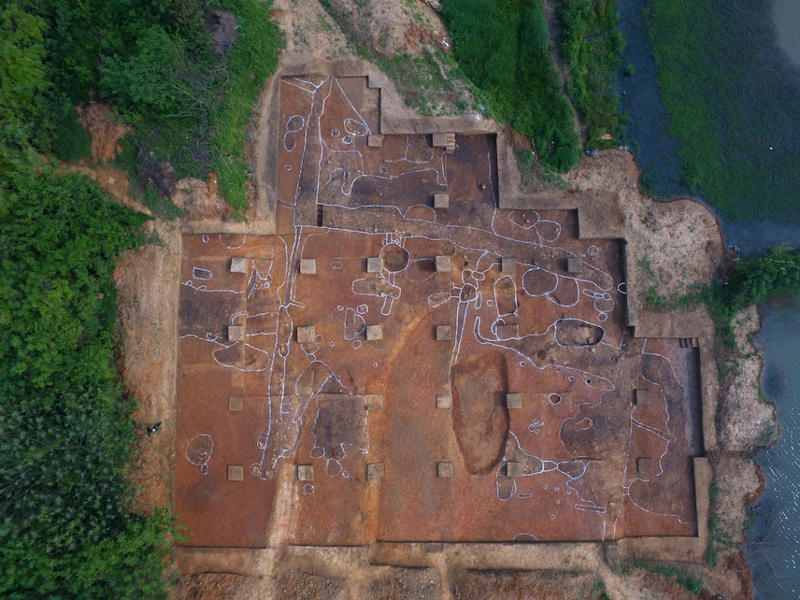
Zhouyuan Site in Baoji, Shaanxi
The Zhouyuan Site is located at the northern junction of Qishan and Fufeng counties in Baoji City, Shaanxi Province. It covers a total area of more than 30 square kilometers and is the largest pre-Zhou cultural settlement and Western Zhou capital settlement. In recent years, the Zhouyuan archaeological team has used the exploration of city wall structure, road network, pond and canal water system, and architectural complex as the "golden key" and "master switch" of field archaeology. Through "large-scale tracking drilling" and "targeted excavation of key areas", a total excavation area of 5,200 square meters has been achieved since 2020, achieving a major breakthrough in settlement archaeology.
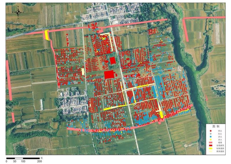
Map of the remains of the Miyagi drilling project
1. The complete exposure of two large rammed earth buildings from the Pre-Zhou period and one from the Warring States period confirms that the Zhouyuan site was a Pre-Zhou capital. In recent years, drilling has discovered a large rammed earth building belt of the pre-Zhou culture in the Wangjiazui area, which is more than 150 meters long from north to south. Building No. 1 in Wangjiazui is a relic of the pre-Zhou culture, consisting of a gate school, east and west wing rooms, a front hall, a back room, and front and back courtyards. The building is 68 meters long from north to south, 34 to 37 meters wide from east to west, and covers an area of more than 2,500 square meters. It is the largest and most complete large-scale rammed earth building of the pre-Zhou culture seen so far, and provides key evidence for confirming that Zhouyuan was the location of the pre-Zhou capital.
According to historical records, Zhouyuan was located in Meiyang during the Warring States Period. In recent years, drilling has discovered more than 300,000 square meters of Warring States ruins at the Zhouyuan site. Building No. 2 in Wangjiazui dates back to the late Warring States Period. It is 41 meters wide from east to west and 30 meters long from north to south, with an area of over 1,200 square meters. It is preliminarily judged to be a large stilt granary. There are thousands of tombs from the Warring States Period in the Liujia Cemetery, and pottery inscriptions of "Meiting" and "Meiyang" have been unearthed many times. The area from Wangjiazui to Liujia should be the location of Meiyang in the Warring States Period. The archaeological discoveries are consistent with the historical records, further confirming that the Zhouyuan site is the place where Gugong Danfu moved to Qi.
Wangjiazui No.1 Building
Second, the discovery of three Western Zhou city walls built in different periods preliminarily revealed the city wall structure of the Zhouyuan settlement, roughly clarified the spatial structure and layout of the Zhouyuan capital, and incorporated the previously scattered large-scale buildings, bronze cellars, tombs, etc. into urban spaces at different levels.
Through continuous field work, it was confirmed that there were three Western Zhou city walls at the Zhouyuan site: the "Palace City", the Small City and the Big City. Both the small town and the palace city were built during the Shang and Zhou dynasties and continued to be used until the late Western Zhou Dynasty. The city was built in the late Western Zhou Dynasty, and three layers of city walls coexisted in the late Western Zhou Dynasty.
The small town is located in the northwest of the site, about 1,480 meters from east to west, about 1,065 meters from north to south, with a direction of 352° and an area of about 1.75 million square meters. None of the Western Zhou city sites discovered in the past were of such a large scale.
The palace is located in the middle of the northern part of the town, sharing the north wall with the town. It is about 800 meters from east to west and about 600 meters from north to south, with an area of 500,000 square meters. There are only a handful of palaces of this scale among the three generations of imperial palaces. Drilling revealed that the palace was filled with rammed earth buildings and many crisscrossing roads.
The big city is located southeast of the small city and covers the core part of the Zhouyuan site. It is about 2,700 meters long from east to west and about 1,800 meters wide from north to south. It has a regular shape, a direction of 352°, and an area of about 5.2 million square meters. Dacheng is the largest city site known in the Western Zhou Dynasty. The large scale of the city site fully demonstrates the capital city status of the Zhouyuan ruins. The triple city wall was different from the capitals of the Xia and Shang dynasties, and it set a precedent for the capital city structure of the Eastern Zhou Dynasty.
East Gate of Ayutthaya and buildings within the city
3. The East Gate of the Great City and the South Gate of the Palace City were fully revealed, filling the gaps in the previous discoveries of the Western Zhou city gates and enriching the understanding of the structural form of ancient Chinese city gates.
The East Gate of the Great City consists of a city platform, an outer city wall, north and south gateways, a gate school, an inner city wall, roads inside the gate and a complex of buildings. The city platform is 94.6 meters long from north to south and 10.5-13 meters wide, with two gates in the south and north. The two roads above the south and north gates will merge into one after entering the city, first intersecting with the north-south road along the city, and then continuing to extend westward. The drilled length is 210 meters and the width is 30-40 meters.
There are building courtyards on the south and north sides of the city road. There are 4 buildings in the southern group, which are arranged in a courtyard style. The bases of the two buildings are covered with rammed earth platforms, with regular shapes and exquisite construction, and they should be official buildings. In the past, there were very few relatively complete and well-preserved Western Zhou cultural architectural courtyards discovered in the country. These two groups of courtyards are precious materials for studying Western Zhou architecture and its rituals.
The entrance to the south gate of the palace is waist-shaped, with 6.5-meter-wide rammed earth walls on both sides. The total depth is about 55 meters and the width is 6-10 meters. There is a piece of rammed earth containing a large number of stones at the narrowest part of the middle section of the gate and at the north end of the gate, which is judged to be the foundation of the two city gates. The southern gate road is inclined, paved with gravel, and has many ruts. The southern moat opposite the gate was originally connected, but it was filled with rammed earth soon after use to form a passage. The rammed earth is 42 meters wide from east to west and 3.6 meters thick. There may have been a city gate building on top, but it is no longer known because it was destroyed by the road ditch of the Han Dynasty.
The excavation of these two city gates has promoted the understanding of the Zhouyuan city form and the level of urban development in the Western Zhou Dynasty, and provided indispensable research materials for the history of China's urban development.
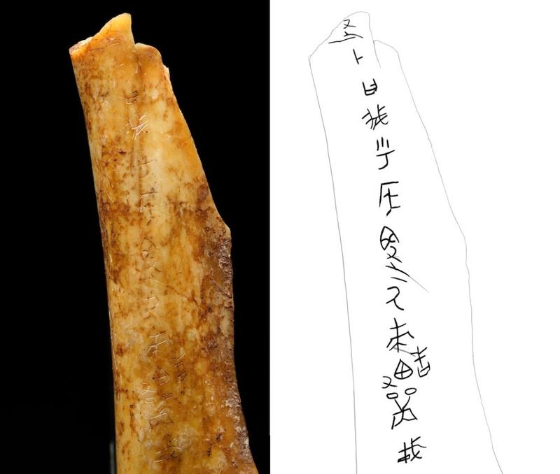
Divination bones with inscriptions
4. A batch of oracle bones from the Western Zhou Dynasty were discovered, which provided many new insights into their shape, age, and content.
213 pieces of oracle bones and tortoise shells were unearthed in the moat outside the south gate of the palace, and 295 characters of inscriptions were preliminarily identified. This is the largest number of Western Zhou oracle bone inscriptions discovered after the Zhouyuan and Zhougong Temple sites. The oracle bone inscriptions are rich in content, covering astronomy and calendar, historical geography, military warfare, numerical hexagrams and many other aspects, and have great historical value.
Royal divination inscriptions from the Western Zhou Dynasty were discovered, such as the inscriptions "The king called and summoned...", "In the year of Ren Zi, the king hunted animals...", etc. The discovery of the name of the moon phase "朏" is the first discovery in unearthed documents, which confirms the credibility of relevant documentary records and is of great value in studying early moon phases and calendars, and restoring the Western Zhou Dynasty. Many names of nations and individuals have been discovered, which can be cross-referenced with bronze inscriptions and handed-down documents.
From the above, it can be seen that this batch of newly discovered oracle bones are rich in content and of great value. They are rare unearthed documents for studying Western Zhou oracle bone studies and history.
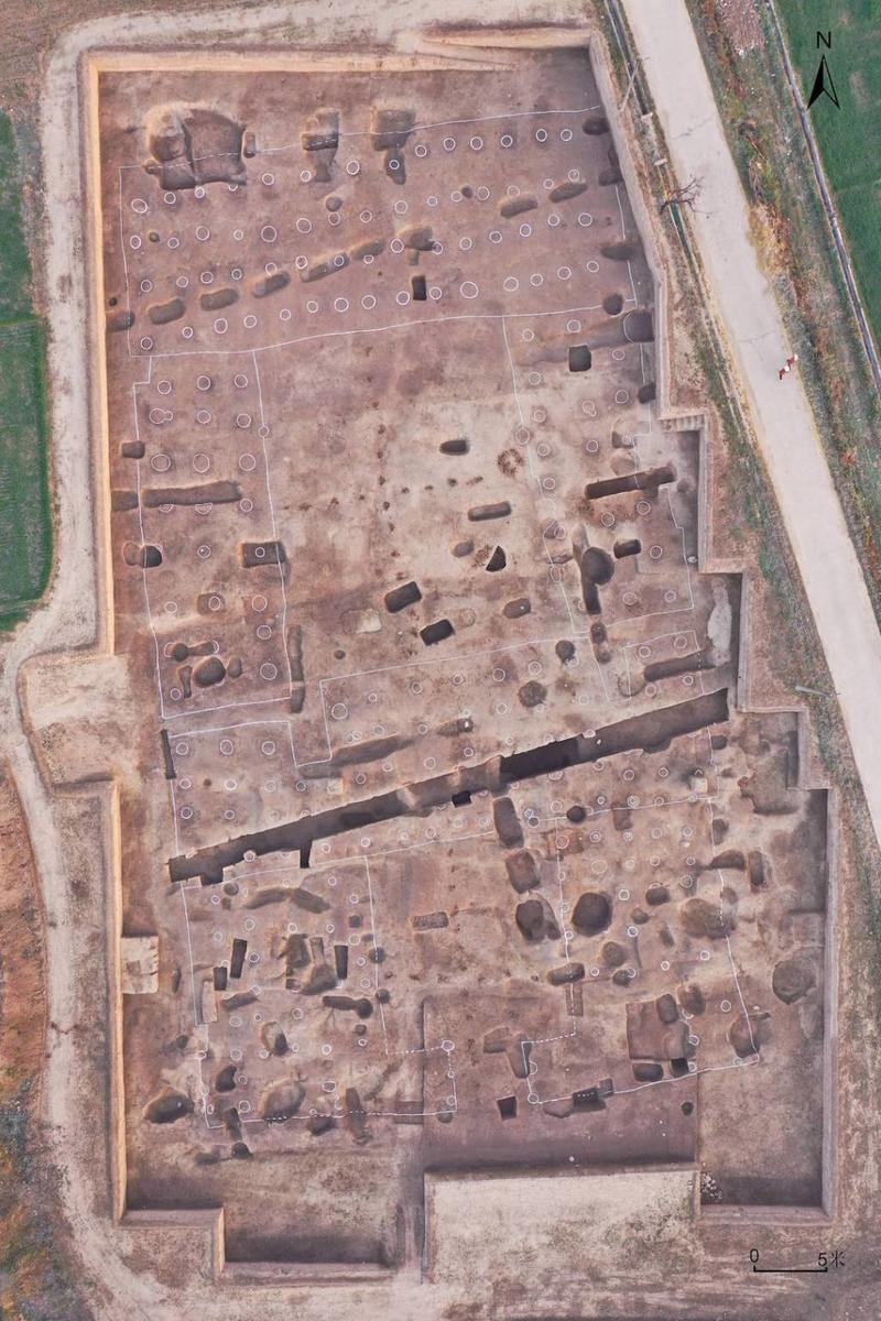
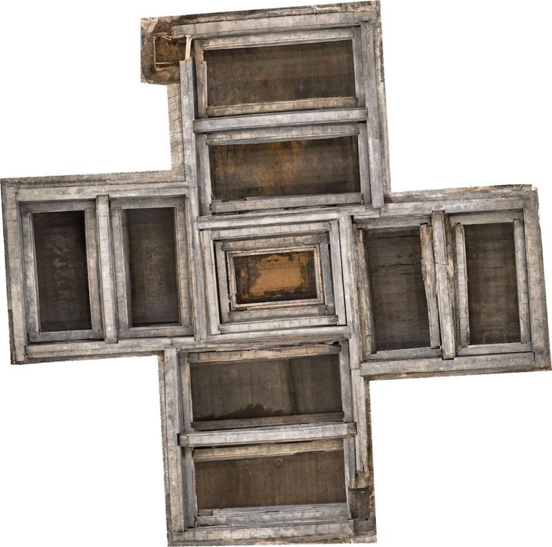
Liulihe Site in Fangshan, Beijing
The Liulihe site is located in Liulihe Town, Fangshan District, Beijing, on the north bank of Dashi River. The main part is remains from the Western Zhou Dynasty, with a distribution area of about 5.25 square kilometers, including Dongjialin, Huangtupo, Liulidian, Lijiao, Huicheng and other villages. It is also the largest Western Zhou site known in the southern foothills of Yanshan Mountain.
Aerial photo of the outer city wall and the northern section of the outer moat
Since 2019, a total of more than 800,000 square meters have been explored, and more than 930 relics of various types, including rammed earth foundations, ash pits, and tombs from the Western Zhou Dynasty have been newly discovered; a total of 3,400 square meters have been excavated, including outer city walls, outer moats, 1 large rammed earth building foundation, 2 large rammed earth wells, 52 tombs, and small house sites, ash pits, etc. New gains and understandings have been obtained in terms of urban layout structure, location and structure of high-level buildings, distribution of tombs of various levels, social organization and livelihood research, etc. are as follows:
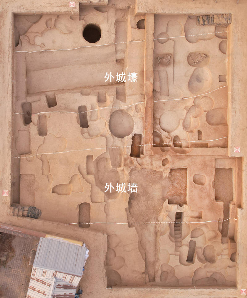
1. The outer moat and the city wall clearly show the double wall structure of the site
In addition to the inner city discovered previously, new outer moats and outer city walls were discovered. The northern and eastern sections of the outer moat are visible, with a proven length of about 1,020 meters. Its west and southeast sides are connected to the Dashi River beach. The northern section is located about 350 meters north of the inner city, with a direction of 82°, which is consistent with the northern section of the inner city wall; the eastern section runs from northwest to southeast. There is an outer city wall on the south side of the northern section of the outer moat, but the surface of the eastern section is severely damaged and no remains of the outer city wall can be seen.
The outer moat has an average width of about 7 to 8 meters, a maximum width of nearly 12 meters, and a maximum depth of about 2.8 meters. The edge of the outer moat is obvious, and the accumulation inside the moat can be divided into 12 to 16 layers: the moat wall is slanted and straight, the bottom of the moat is almost flat, and there is silt at the bottom, indicating that water once flowed through it, and there is artificial ash and soil on top. There are 8 sacrificial cattle pits under the openings of the 2nd and 3rd accumulation layers in the moat, and there are also whole sheep, pigs, dogs, etc. buried in the moat.
The outer city wall was found in two excavation sites in the northern section, located 3 to 5 meters away from the south side of the outer moat. It has a remaining width of 6 to 9 meters, with only the bottom of the foundation trench remaining. It was rammed earth with visible traces of rammed earth, and the remaining depth is 20 to 30 centimeters.
According to the breaking relationship, unearthed relics and carbon-14 dating results, the moat was used around the early Western Zhou Dynasty and was abandoned before the middle Western Zhou Dynasty. Based on the location of the outer moat, it is estimated that the city site could reach a million square meters.
Horse bridle ornaments unearthed from the large noble tomb M2401
2. Large-scale rammed earth facilities reveal the scale and structure of high-level building complexes
Only the underground foundation remains of the large rammed earth building site JZ2. The raw soil was dug out of the foundation pit and filled with rammed earth. The rammed earth can be divided into three types according to its texture and craftsmanship. Type C rammed earth is the earliest, and according to carbon-14 dating results it is from the early Western Zhou Dynasty. It is rammed earth made of yellow raw earth with clear rammed blocks and obvious rammed holes. The thickest part of the rammed earth is about 2.3 meters, the rammed layer is 6 to 10 centimeters thick, and the diameter of the rammed hole is 2 to 4 centimeters. It is suspected that it was rammed by bundled wooden sticks. The eastern boundary of Type B rammed earth is the same as that of Type C rammed earth, and may be an extension. The rammed earth in this period was composed of alternating cyan clay and yellow raw soil. The cyan clay was found 5 meters underground at the site, and may have been dug at the same time as the wells were being dug in the surrounding area. Type A rammed earth is the latest, and the rammed earth construction phenomenon is not obvious. The rammed earth layer is 10 to 15 cm thick and contains a large amount of wood ash, red-burnt earth blocks, etc. The quality of the rammed earth has obviously declined. The latest pottery fragments unearthed date back to the middle and late Western Zhou Dynasty.
There is a large rammed earth well HJ3 and HJ4 to the south and northeast of JZ2, each of which is more than 10 meters deep. The rammed earth area inside the earthen mound outside the well is nearly circular, with an area of 532 to 560 square meters, which is huge in scale. The HJ3 well mouth has collapsed, with a diameter of about 3 meters and a paved surface made of large and small pebbles around it. There are two column bases in the northeast outside the well mouth; there are three north-south standing stone belts in the southwest, with a spacing of 2.4 to 2.5 meters, which may be the road edging; there is a pool breaking the rammed earth in the southeast outside the well. The pool was broken by an ash pit in the late Western Zhou Dynasty. The remaining part is a rounded rectangle, 7.5 meters long from east to west and 4.5 meters wide from north to south. The walls are slanted and straight, and the bottom and walls of the pool are paved with neatly arranged large pebbles. On the west side there is a horse pit breaking the edge of the rammed earth.
High-grade relics such as inscribed oracle tortoise shells, inscribed oracle bones, primitive porcelain fragments, bronze container pottery molds, pottery moulds, as well as high-grade building materials such as tiles with tile nails, wall coverings, and red-baked earth blocks were unearthed in the Western Zhou ruins in this building area.
Ten large rammed-earth wells were newly discovered in the inner city. The diameter of the rammed earth is more than 15 meters. Some of them have supporting facilities and are scattered throughout the city. They may be the identifying elements of an urban unit and provide clues for exploring the urban divisions and the li system of the Western Zhou Dynasty.
Lacquer bean bucket, spoon and plate combination unearthed from the large noble tomb M2401
3. Groups of large tombs confirm the cemetery of the Yanhou family
Based on the systematic review of previous results, this stage of work conducted a systematic exploration of the north of Huangtupo Village, and discovered a total of 17 tombs with passages, including 4 tombs with "angled passages", 4 tombs with double passages in the shape of the Chinese character "Zhong", and 9 tombs with single passages in the shape of the Chinese character "Jia". It is speculated that they are the cemetery of the Yanhou family. M1193, where the Ke Li and Ke Lei were unearthed, and M202, a "Zhong"-shaped tomb, are located at the western end of the Yanhou Tombs.
The discovery of the Yanhou Tombs fills in the most critical link in the distribution pattern of aristocratic tombs. From this, we can roughly infer the duration of the Liulihe site as the capital of the Yan State, and provide important archaeological basis for filling the gap in the Yanhou lineage.

Combination of ceremonial vessels and inscriptions
4. Civilian cemeteries explored the grassroots social organization structure of the Western Zhou Dynasty
During this phase of work, a number of small civilian cemeteries were newly discovered outside the inner city. Unlike the concentrated distribution of aristocratic tombs in Huangtupo Village, these cemeteries are distributed in clusters on the east and north sides of the inner city.
A civilian cemetery was discovered and exposed in the north of the city, and 33 small tombs were excavated, all of which were rectangular vertical pit tombs. The main direction of tombs is north-south. Most of the burial objects are single coffins, and a few are one coffin and one outer coffin. The tomb owners included both men and women, most of whom were adults, and the main burial style was supine burial with limbs straight. Most of the burial objects are single tripods or a combination of tripods, gui and jars. Some tombs had dogs buried in waist pits or in the filling soil, and some even had the left front legs of animals buried with them, which reflects strong Shang culture elements. The carbon and nitrogen isotope ratios of the bones of the tomb owners in this cemetery are significantly lower than those in the Huangtupo aristocratic burial area, which is consistent with the tomb owners' civilian status.
Using the latest method of high-resolution kinship identification of the entire human genome, a four-generation family tree was identified in the cemetery, which showed that the family relationship in the cemetery was based on paternal inheritance and that there was a phenomenon of consanguineous marriage. This is the first family tree reconstructed in the field of Shang and Zhou archaeology in China. It provides a new technical route for studying the tomb arrangement and organizational structure that are of concern to Shang and Zhou archaeology, and is a major breakthrough in the study of ancient family relationships and social structures.
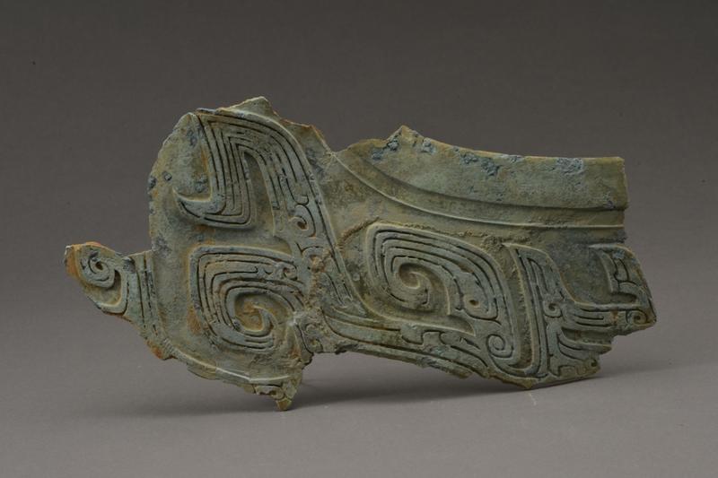
Tomb No. 1 of Wuwangdun, Huainan, Anhui
Wuwangdun Tomb is located in Sanhe Town, Huainan City, Anhui Province. It is a large cemetery of the Chu State in the late Warring States Period. Archaeological exploration has confirmed the existence of an independent cemetery in the Wuwangdun Cemetery. The cemetery is located on a north-south hill, covers an area of about 1.5 million square meters, and is surrounded by a moat with a circumference of nearly 5,000 meters. In addition to the main tomb No. 1, the cemetery also has large chariot and horse pits, large burial tombs, sacrificial pits and other related relics.
Tomb No. 1 is a large "A-shaped" vertical pit tomb. The funnel-shaped mound is about 134cm long from east to west, 114cm wide from north to south, and 14cm high. Meter. The opening of the tomb is nearly square, with a side length of 51 meters. There is a sloping tomb passage about 42 meters long on the east side. There are 21 steps on the four walls of the tomb, which gradually retract to the top of the tomb pit. The filling soil is compacted layer by layer, and the rammed earth holes are clear and dense. The tomb pit is nearly square, with a side length of about 23 meters. In the center is a "Y"-shaped wooden coffin chamber built with long square wood strips. The four corners are filled with earth, and bamboo mats are laid on the pit walls, the four corners of the filling and the cover of the wooden coffin chamber.
The coffin chamber after the extraction of the artifacts (the top is north)
The wooden coffin chamber of Wuwangdun Tomb No. 1 is the first complete nine-chamber multi-coffin chamber. It is built of square wood and thin boards and is generally in the shape of a "Y" character, with the coffin chamber in the middle and two sub-chambers in the east, west, south and north, separated by partitions. The sub-chambers have independent walls, for a total of nine chambers. There are various techniques for building coffins, including stacking, paving, buckling, overlapping, nested mortise and tenon joints, and dovetail mortise and tenon joints. The outer coffin is made of plain wood and the coffin is lacquered. Ink writing was found on the coffin wood, which is the largest, highest-level and most content-rich pre-Qin ink writing discovered in China so far. The coffin chamber cover, wall panels and bottom panels are all written on, and the content format is basically the same, divided into four parts: the orientation of the coffin wood, the name of the chamber, the nature of the coffin wood, and the coffin wood number. Conical chiseling marks can be observed at the joints of the cover plate, wall plate and bottom plate, with the spacing between the marks wider at one end and narrower at the other. There is a corresponding relationship between the ink-written text numbers and the engraving marks: the smaller the number, the narrower the spacing between the engraving marks.
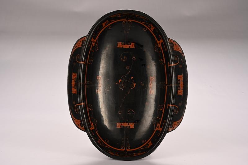
Lacquer ear cup
More than 10,000 artifacts were unearthed from Wuwangdun Tomb No. 1, including basically complete ritual containers and musical instruments, a well-preserved "wooden figurine pit" with rich artifacts, as well as a large number of lacquered wooden daily necessities, chariots and weapons, jade artifacts, oracle bones, etc. The types are all-encompassing, providing rich information for understanding the material civilization of the Chu State.
The ritual vessels were mainly buried in East Room I and East Room II. The East I Room is well preserved, and 154 bronze wares of various types were unearthed. The types are relatively complete, including tripods, gui, fu, dun, dou, yan, plates, yi, pots, fangs, mirrors, zun guan, yu guan, and stoves. There are 44 bronze tripods in total, the core of which are groups of nine with waisted flat-bottomed tripods, groups of seven with lying-ox-buttoned mother-and-child-shaped lidded tripods, groups of three with wok tripods, and groups of three with hoop-mouthed tripods. The basic combination of utensils is nine sheng ding, eight gui and eight fu, seven lying ox-button ding, six dou and six dun, three wok ding and three hoop-mouth ding.
The ritual and musical instruments were mainly buried in the North Room and West Room II. Based on the unearthed artifacts and recovered cultural relics, the overall picture of the instrument combination can be basically restored. The sound-producing components of the unearthed musical instruments are complete, and some of them show signs of use. Materials include copper, stone, lacquered wood, and gourd bamboo. The appearance of musical instruments has changed greatly compared with the high-level Chu tombs in the early and middle Warring States period. The large combination of chime bells has been replaced by a large number of string and bamboo instruments, vividly presenting the development and evolution of the ritual and music culture of the Chu State in the Warring States period.
The western chamber of Wuwangdun Tomb No. 1 consists of two basically intact "wooden figurine pits", from which more than 280 wooden figurines were unearthed. Some of the figurines had painted faces and textile remains. Among them, West Room I was preliminarily speculated to be a ceremonial figurine room, with more than 80 wooden figurines unearthed, including a lacquered wooden model chariot, a wooden model sword, and a 竽; West Room II was preliminarily speculated to be a singing and dancing figurine room, with more than 200 wooden figurines unearthed, including a lacquered wooden model chariot, a se, and a 竽. The wooden figurines in Tomb No. 1 of Wuwangdun are large in scale, diverse in variety, well-preserved, and contain a rich variety of artifacts. They are the first of their kind found in a Chu tomb and should be a posthumous representation of the tomb owner's travel ceremonial guards and music and dance troupes.
Big Ding
After preliminary sorting and statistics, the largest number of unearthed artifacts are lacquered wooden daily utensils, with exquisite craftsmanship and beautiful patterns. The shapes include tables, sacrificial tables, ear cups, boxes, bowls, plates, etc. The jade artifacts were mainly buried in the South Room, East Room II, and the Middle Room. Most of them were jade ornaments, and some were jade funerals. Some of the artifacts showed obvious signs of modification. The utensils include jade bi, jade rings, jade huang, jade tubes, jade heng, jade dragons, jade belt hooks, jade hairpins, etc. In addition, a large number of oracle shells were discovered, mainly buried in the south room. A preliminary analysis showed that 7 carapaces and 48 plastrons were pieced together, and ink inscriptions were found on a small number of oracle shells. There are traces of drilling and chiseling on the back of the plastron and traces of patterns on the front. The drills are all square with regular edges, and most of them have a vertical groove in the middle. Wuwangdun Tomb No. 1 also unearthed textual materials with rich carriers and diverse contents, including ink-written characters on the coffin wood, inscriptions engraved on bronze ware, needle-carved characters on lacquerware, painted characters, and bamboo slips.
During the excavation of the coffin chamber of Tomb No. 1 in Wuwangdun, the collation of excavation data, multidisciplinary research and protection of unearthed cultural relics were carried out simultaneously. A large number of animal and plant remains were found in the bronze and lacquered wooden objects in East Room I. So far, 17 animal species have been identified, including cattle, sheep, pigs, dogs, deer, chickens, fish, etc. There are 13 species of plant remains in three categories: melons, fruits and spices. In addition, more than 200 plant bags were extracted in the East I room. The crops millet, sorghum and rice (all in shells) were mainly wrapped in oak leaves and buried with the dead. Rice was the largest in number, while millet and sorghum were less numerous.
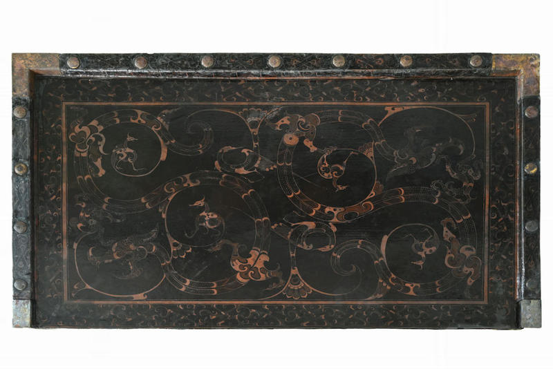
Painted copper-edged lacquered wood table
The Wuwangdun Tomb is the largest, highest-level and most complex large-scale high-level tomb of the Chu State that has been scientifically excavated to date. It provides systematic archaeological data for the study of the high-level tomb system of the Chu State in the late Warring States Period, as well as the historical culture of the Chu State after its eastward migration. After nearly five years of archaeological exploration, excavation, collation and research, combined with comprehensive analysis of historical documents, the owner of Tomb No. 1 was "Xiong Yuan", King Kaolie of Chu, as recorded in "Records of the Grand Historian: The Family of Chu", providing an important time and space coordinate for future related research.
Hebosuo Site in Jinning, Yunnan
1. Overview of the Site
The Hebosuo site is located in the most fertile southeastern lakeside alluvial plain of the Dianchi Basin, bordering Guanling to the east and Dianchi Lake to the west. The total area of the site is about 12 square kilometers, with a core area of about 3 square kilometers. It is only 700 meters northeast of the Shizhaishan ancient tombs where the "Seal of the King of Dian" was unearthed. It is the largest, longest-lasting, and culturally rich large-scale central settlement site on the Yunnan Plateau from the Shang and Zhou Dynasties to the Han and Jin Dynasties.
The central Yunnan region where the Hebosuo site is located is the core distribution area of the Shizhaishan culture (commonly known as the Dian culture). Four archaeological excavations of the Shizhaishan Ancient Tombs in the 1950s and 1960s revealed the unique features and rich connotations of the Shizhaishan culture, clarified that the Shizhaishan Ancient Tombs were the highest-level cemetery of the ancient Dian Kingdom, and verified the records of the history of the Dian Kingdom in the literature.
In 2014, the "Shizhaishan Ancient Tombs Archaeological Work Plan" was approved for implementation, and archaeological work continued around the Shizhaishan Ancient Tombs and the Heboso site. As of December 2024, the site has excavated a total area of 10,000 square meters, unearthed more than 9,000 relics of various types, and achieved a series of major breakthroughs.
City walls during the Han Dynasty
2. Results of preliminary work
Through large-scale archaeological surveys, general exploration and key drilling, the macro-settlement form and structural layout of the site have been basically clarified. The Hebosuo site has a superior geographical location and is carefully sited. The site is adjacent to the vast waters of Dianchi Lake in the west, and is surrounded by four independent mountains, Liangwang, Zuowei, Jinsha and Longtan, from north to south in the east, forming a relatively closed geographical space. The Hebosuo site, which serves as the central settlement, and Shizhaishan, a high-level cemetery, are located in the center. Due to the abundant water resources, the Hebosuo site was divided into multiple terraces of different sizes and shapes by the vast water system. The terraces were separated and connected by rivers, forming a unique settlement cultural landscape with interwoven river networks and scattered terraces. There are rich cultural deposits on the plateau. Through archaeological excavations, various functional areas such as residential areas, sacrificial areas, and handicraft areas have been discovered in the western part of the Heboso site. The cultural features are closely related to the Shizhaishan culture. This area is very likely to be the capital of the ancient Dian Kingdom. In the eastern part of the Heboso site (now the site of Shangsuan No. 1 Primary School), clues to the seat of Yizhou County in the Han Dynasty were found.
Large wooden structure ruins (photographed from west to east)
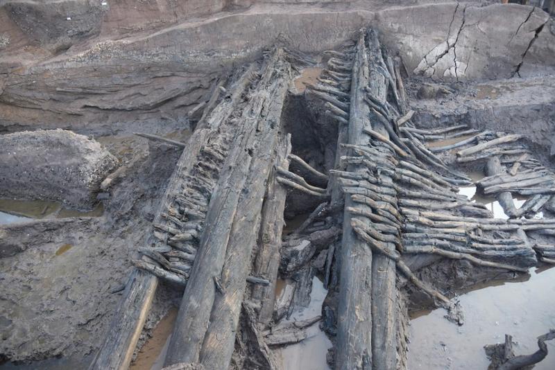
3. Important Findings
1. The main structural layout of the Yizhou County city site was clarified
The core accumulation area of the city site was identified through drilling. It has a square plan and covers an area of about 180,000 square meters. A moat with a circumference of about 1,800 meters was found outside the accumulation area. Excavations in the southwest of the core accumulation area revealed continuously superimposed city walls and trench structures from the Han and Wei and Jin dynasties, as well as dam walls and large wooden structure remains from the Eastern Zhou Dynasty.
2. Preliminary disclosure of the main functional divisions within the city
In the southwest of the core accumulation area, functional divisions such as main roads, building areas and rivers from the Han and Jin Dynasties were revealed. The building area is located on the north and south sides of the road, and architectural remains from the Han, Wei and Jin dynasties have been discovered. The former is the most important and can be divided into two periods, early and late. On the piled loess platform, relics such as column pits, column base stones, drainage, wells and ash pits were found. A large number of building materials such as tubular tiles, flat tiles, bricks, etc. were unearthed. The weight of tiles reached 120 tons. There are important relics such as tiles with "Yizhou" inscription, seals, and bamboo slips with words.

Sealing mud
3. Determine the exact location of Yizhou County
More than 1,900 seals from the Han Dynasty were discovered, including seals related to the ancient Dian Kingdom, such as "Seal of the Prime Minister of the Dian Kingdom" and "Seal of the Prime Minister of the King of Dian"; seals of southwestern border counties, such as "Seal of the Prefect of Yizhou", "Inspector of Yizhou", "Seal of the Prefect of Guanghan" and "Seal of the Prefect of Jiaozhi"; and seals of 24 counties under the jurisdiction of Yizhou County, including Dianchi, Yuyuan and Yunnan. More than 50,000 bamboo slips were discovered, including more than 5,000 with inscriptions, which is the largest batch of unearthed documents in Yunnan. The contents of the bamboo slips include proclamations, official correspondence, judicial documents, household registers, name lists, letters and classics, involving the establishment of political regions, the official system, the tax system, the judicial system and ethnic relations.
In addition, other important relics were unearthed, including "Yizhou" inscribed tiles, "Changle" tiles, dated tiles, cloud pattern tiles, patterned bricks, and floor tiles.
The city walls, moats, large wooden structure remains discovered at the Hebosuo site, as well as important relics unearthed such as roof tiles with the inscription "Yizhou", seals, bamboo slips, etc., provide archaeological evidence for the accurate determination of the Yizhou County seat, indicating that the location of Shangsuan No. 1 Primary School was the seat of Yizhou County in the Han Dynasty.
IV. Important Value and Significance
1. A series of major discoveries from the Shang and Zhou Dynasties to the Han and Jin Dynasties at the Hebosuo site have clarified the development and evolution of archaeological culture in central Yunnan from the Shang and Zhou Dynasties to the Qin and Han Dynasties, and deepened the understanding of the ancient historical and cultural features of the Yunnan-Guizhou Plateau. It is the latest achievement in southwestern frontier archaeology in recent years.
2. The continuously stacked city walls and large wooden structure remains from the Spring and Autumn Period to the Wei and Jin Dynasties discovered at the Hebosuo site, the main roads and high-grade building areas within the city, as well as the unearthed "Yizhou" inscribed tiles, "Yizhou Taishou Seal" and other official seals and a large number of inscribed bamboo slips, provide important archaeological evidence for the accurate determination of the location of the Yizhou County in the Han Dynasty.
3. The major archaeological discoveries at the Hebosuo site bear witness to the history of interaction, exchange and integration between the southwestern frontier and the Central Plains. It is a typical example of the historical process of the southwestern frontier's integration from "diversity" to the "integration" of Chinese civilization. The discovery of "counties, towns, townships, and villages" from the Qin and Han dynasties in bamboo slips fills the gap in archaeological records of the county system from the Qin and Han dynasties, and provides archaeological evidence for in-depth research on the local administrative system and grassroots organizations from the Qin and Han dynasties.
4. The seals and bamboo slips unearthed from the Hebosuo site provide evidence of historical facts such as "Yizhou County was established in the Western Han Dynasty" and "it governed 24 counties". The words "Dian Kingdom", "Dian Prime Minister" and "Dian Prime Minister" interpreted in the bamboo slips are mutually confirmed by the "Seal of the King of Dian" and "Seal of the Prime Minister of Dian Kingdom" unearthed previously, indicating that the central dynasty of the Western Han Dynasty implemented a relatively flexible dual political structure and soft control governance strategy in Yunnan. While strengthening central power, it also promoted the stability and development of border areas. It is a vivid portrayal of the inclusiveness and peace, two of the five outstanding characteristics of Chinese civilization, and has outstanding and significant value for studying the governance of the southwestern border and the nationalization process during the Qin and Han Dynasties.
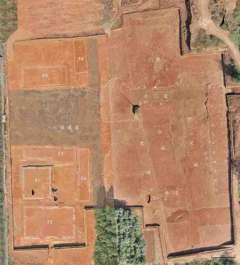
Kashgar More Temple Ruins in Xinjiang
1. Overview of the Site
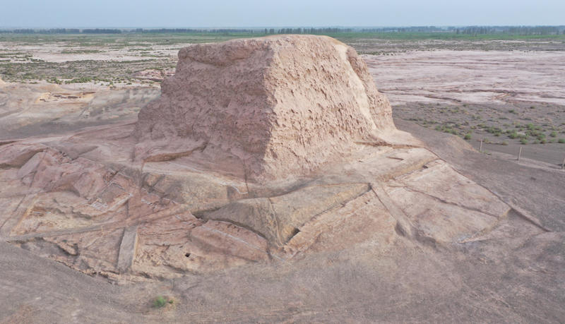
The More Ruins are located 33 kilometers northeast of Kashgar City, Xinjiang, on the alluvial terrace southeast of Gumatag Mountain. It is an important Buddhist temple site of Shule, an ancient city-state in the Western Regions of my country, and is also a national key cultural relic protection unit. Since 2019, Minzu University of China and Xinjiang Institute of Cultural Relics and Archaeology have carried out six excavations at the site and achieved many significant results.

View of Moer Temple
II. Major Archaeological Findings
1. The temple complex is fully exposed, and the structural characteristics of the main buildings are clearly identified.
The site covers an area of about 20,000 square meters, and the relics are mainly distributed on two adjacent terraces. Archaeological excavations have revealed the remains of a dense complex of buildings, including the bases of two pagodas, 18 individual buildings with a total of 62 rooms and two stepped stairways. These buildings are all built with adobe, some of which have shallow foundation pits. The walls and floors are mostly covered with grass and mud and painted with white lime.
The 18 individual buildings can be divided into monks' quarters, corridor-style Buddhist temples, rectangular large Buddha halls, lecture halls, kitchens and their storage rooms, and restaurants. A collapsed vault structure was found in the mountain gate building leading to the top of the 13-step staircase on the east side. A side gallery on the south side of the building leads to the rest of the buildings on top of the terrace. A mud tile was also unearthed at the site, providing clues to the sloping roof and showing the influence of Central Plains architecture.
(ii) Clarifying the structure of the pagoda and updating our understanding of the pagoda
The two pagodas, one round and one square, are the iconic buildings of the Moer Temple ruins. The dissection of the deposits at the bottom of the pagodas showed that there were two layers of pedestals and square platforms under the two pagodas, and the side length of the square pagoda platform was 39.36 meters. These discoveries updated the original understanding that the round tower had a three-story square base and that the square tower had three stories.
(III) Determine the era of rise and fall and clarify the changes in layout
The temple buildings are mainly distributed in the southwest of the large platform and the small platform, with the cliffs around the platform as natural barriers and no walls. Remains of artificial ground and drainage ditches were found under the northern slope of the small terrace. There are 11 groups of broken and superimposed relationships between different buildings. Combining the unearthed relics and carbon-14 dating, it is clear that the site was built in the 1st century AD and abandoned around the end of the 9th century and the beginning of the 10th century. It lasted for about 900 years and can be divided into two periods:
The initial construction period was from the 1st to 3rd century AD, including the mountain gate steps, foundation No. X (mountain gate building), foundations No. I, II (left half), V, and XII (monks' quarters), the round tower and its nearby building No. VII (tower hall). The round pagoda is the center of worship, with monasteries distributed nearby or on the side. This is a type of floor plan that originated in India shortly after the Buddha's death.
The period from the 4th century until its abandonment was a period of integration, during which various types of Buddhist temples, kitchens, lecture halls and square pagodas were added. The worship center was transformed into one that emphasized both pagodas and temples, and there appeared a fusion of cultural elements from India, Central Asia, Gandhara, local areas and the Central Plains.
4. Unearthed relics and historical and cultural reflections
The unearthed relics are rich, covering categories such as pottery, bronze, stone, wood, bone, textiles, as well as Jianlun Wuzhu, Kaiyuan Tongbao, Qiuci small coins and plaster Buddhist statue fragments, totaling more than 30,000 pieces. The wooden carving of the six-toed Buddha's foot reminds people of the record in the Book of Sui that the King of Shule had "six fingers on both hands and feet", and the clay tiles reflect the influence of Central Plains architecture. A plaster Buddha statue with a plump face combines the features of Gandhara and Central Plains Buddha statues. The 41-centimeter-long Buddha palm indicates that the statue is twice the size of a real person.
(V) Multidisciplinary research and the revelation of temple life and ancient environmental changes
Identification of animal bones showed that they were mainly sheep, cattle and horse bones, confirming the record that Shule monks ate meat; 18 kinds of fruits and vegetables were identified; and pollen analysis found more than 40 genera of plant species, providing important data for the study of desert environmental changes. Most of the building materials are local poplar and willow wood.
Square Tower
3. Important Academic Value and Practical Significance
1. This is the westernmost, oldest, longest-lasting, most clearly developed and relatively well-preserved large-scale ground-based Buddhist temple site discovered in my country so far. It is a typical representative of early large-scale ground-based Buddhist temples, providing a sample of the layout of early Buddhist temples in my country and their development and evolution, and promoting the study of ancient Shule and Silk Road Buddhist archaeology and the origin of early Buddhist temples in my country.
2. The site is located at the intersection of the northern and southern Silk Roads. It was the first stop for the spread of Buddhism to my country. It integrates multiple cultural elements from India, Gandhara, Central Asia, local culture and the Central Plains. Many signs indicate that it is related to the Han Dayun Temple built during the Wu Zhou period. The local characteristics and the influence of the Central Plains indicate that the process of Buddhism's sinicization began when it entered the Western Regions, providing a new model for the sinicization of Buddhism and confirming the exchange and mutual learning of civilizations and the inclusiveness of Chinese civilization.
3. The coexistence of multiple religions and the effective governance of the Western Regions by the central dynasty are of special significance for strengthening the sense of community of the Chinese nation.
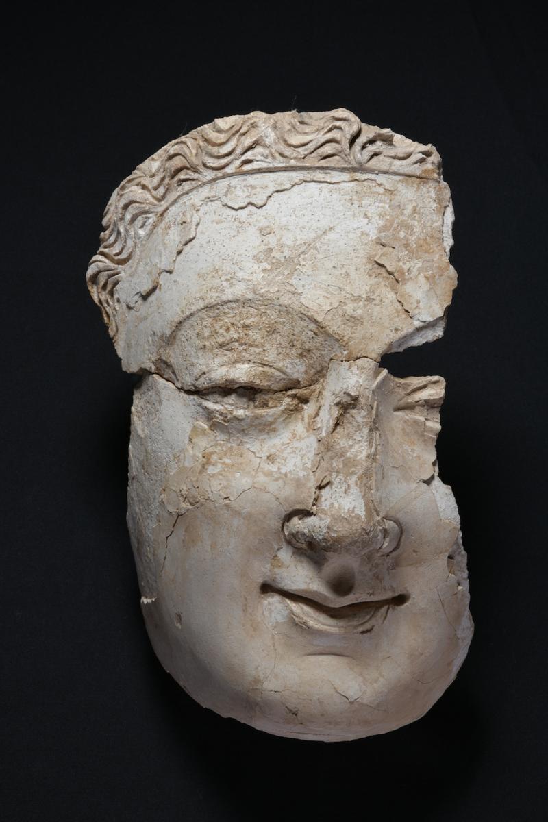
Plaster Buddha face
Wooden Buddha Foot
4. Emphasis on protection and dissemination, and give full play to the contemporary value of cultural relics
1. Adhering to the concept of simultaneous excavation, protection and dissemination, we simultaneously studied and compiled the protection and utilization plan of the Moer Temple Ruins, which has been approved by the State Administration of Cultural Heritage in 2024; and promoted the application for the autonomous region's archaeological site park.
2. More than 10 academic papers and 10 dissertations have been published; 6 special edition reports have been published in newspapers such as People's Daily, and more than 50 publicity reports have been made by central and local radio and television and new media; the "International Forum on the History and Future of Xinjiang" was successfully held, and the archaeological results have caused a huge response at home and abroad.